Revista Produção e Desenvolvimento, v.4, n.3, p.62-72, 2018
DOI: https://doi.org/10.32358/rpd.2018.v4.276
THE SUSCEPTIBILITY OF LANDSLIDE HAZARD MANAGEMENT & MITIGATION MEASURES VIA MALAYSIAN PWD OPERATIONAL CAPABILITIES & NSMP 2009-2022
|
ANAS ALNAIMAT1*; MOKHTAR JAAFAR2; KUOK CHOY LAM2
1. Environmental Management Programme, Universiti Kebangsaan Malaysia, Faculty of Social Sciences and Humanities, 43600 Bangi, Selangor, Malaysia
2. Social, Environmental and Developmental Sustainability Research Centre, Universiti Kebangsaan Malaysia, Faculty of Social Sciences and Humanities, 43600 Bangi, Selangor, Malaysia
|
|
Submitted at 17/01/2018 and accepted at 07/04/2018 |
ABSTRACT
In recent years Malaysian government has started to pay more attention to the landslide issues, as public outcries grew louder. Some local authorities that are at the front line of public anger whenever major landslides occurred have yet to provide better services while others utilized guidelines and relevant acts to act against errant developers and land owners. As a consequence of this, Public Works Department (PWD) and its Slope Engineering Branch (CKC) will require training, not only in the procedures themselves, but also in regards to the basis of landslide mechanisms, landslide risk assessment and dealing with geotechnical reports at best professional manner. In addition to the success of implementing for the National Slope Master Plan NSMP 2009-2023 would depend on every stakeholder and relevant authorities that includes the public residents and most of all the political parties of the Malaysian government and it is therefore local government and other regulators must establish strong internal procedures for dealing with land use and development proposals on land situated within a landslide susceptibility. Hence, here comes the significance to further examine and assess the value of Malaysian NSMP as being comprehensive national disaster management strategy and a constitution of landside mitigation measures.
|
KEYWORDS: Landslide susceptibility, Risk assessment, Hazard management, National Slope Master Plan NSMP, Operational capabilities PWD. |
1. INTRODUCTION
In tropical zones landslides and floods are two major natural disasters that have impacted the countries in terms of injuries, deaths, property damage, disruption and destruction of services, public inconvenience and economic as well as financial losses (Alnaimat et al, 2017). While flood events are currently monitored and managed under a national framework for flood management, landslide events do not benefit from the same attention (Ibrahim Komoo et al, 2011).
In Malaysia the causes of landslides are usually related to instabilities in slopes (Li et al, 2011). It is usually possible to identify one or more landslide causes and one landslide trigger; the difference between these two concepts is subtle but important (Jasmi, 1996). Also landslide is associated with: steep slopes, permeable rocks, water in the soil, rock and human activity. The trigger is the single event that finally initiated the landslide. Thus, causes combine to make a slope vulnerable to failure, and the trigger finally initiates the movement. Landslides can have many causes but can only have one trigger (Dorren et al, 2006). Hence probabilistic techniques are most suitable option to quantify and incorporate uncertainty into slope analysis and design as compared to the traditional loom of safety factor (Saro & Biswajeet, 2006).
In recent years, landslip risk analysis and management has become an important tool in addressing uncertainty inherent in landslide hazards. The advanced multivariate techniques are proved to be effective in spatial prediction of landslides with high degree of accuracy. Physical process based models also perform well in hazards mapping even in the areas with poor database. Multi-criteria decision making approach also play significant role in determining relative importance of landslide causative factors in slope instability process (PARDESHI et al, 2013).
However, despite all of the advance methods and techniques in spatial prediction of landslides it is extremely difficult to predict landslide hazards in absolute terms (Oven, 2009). As a consequence of this evaluation research and socio-economic development planning are necessary to establish the effectiveness of public affairs programs and their contribution to organizational effectiveness (Yin et al;, 2012). It provides the vital information necessary to plan public relation actions. Management demands hard facts, not intuition or guesswork.
2. LARGE SCALE LANDSLIDES IN MALAYSIA
The earliest recorded landslide in Malaysia occurred on 7 December 1919, which claimed 12 lives (JKR, 2009). After the country gained independence in 1957, the first national tragedy was a landslide at Ringlet, Cameron Highlands that occurred on 11 May 1961. About 700 people and two bulldozers came to assist and approximately 30 people were rescued. This tragedy, however, claimed 16 lives. From 1973 onwards, a considerable number of landslides were reported in the local newspapers. Reported landslides and fatalities from 1973 to 2007 indicate an increase in the number of fatalities with an increase in the number of landslides. However, the highest fatality recorded for a single landslide event, was on 26 December 1996 where a debris flow caused by Tropical Storm Gregg wiped out a few villages in Keningau, Sabah and claimed 302 lives.
It’s therefore necessary to remain up to date collecting historical landslide data from various sites. However, the present historical landslide database provides little knowledge for better understanding on landslides in the Peninsular, Kuala Lumpur and its surrounding. Recent report by ExpactGo (2015) claims that a total of 1740 slopes in Kuala Lumpur are prone to landslides. The exact number, according to Kuala Lumpur Mayor Datuk Seri Ahmad Phesal Talib, was derived from the Kuala Lumpur Slope Information System (KuLSIS) study made on landslide-prone slopes.
Among the 1740 hill slopes, at least 620 were classified as very high risk while the rest was high risk. According to KuLSIS, the Segambut parliamentary constituency recorded the highest number of hill slopes at 713, of which 219 are very high-risk areas and 494 high risk, followed by Lembah Pantai with 315 hill slopes, Bandar Tun Razak (183), Seputeh (132), Setiawangsa (125), Bukit Bintang (90), Kepong (70), Wangsa Maju (56), Cheras (45) and Batu (11). Whereas the report concluded, there are eight slopes under repair from landslide incidents in Kuala Lumpur. Out of the eight, the cost of repairs for three slopes (Taman Salak Jaya, Lorong Setiabistari and Jalan Tuba) amounted to RM4.6 million.
3. LANDSLIDE HAZARD ASSESSMENT AND RISK REDUCTION
Landslide risk is a measure of the chance of occurrence of slope failure causing a certain amount of harm (e.g. fatalities and economic losses), and can be quantified as the product of the probability and consequence of failure (GEO, 2003). Landslide risk assessment is the process of identifying the landslide hazard and estimation of the risk of the hazard. Landslide Risk Management (LRM) comprises an estimation of the landslide risk, deciding whether or not the risk is tolerable, and exercising appropriate control measures to reduce the risk where the risk level cannot be tolerated (Wong & Ko, 2006). In a more global context, LRM also refers to the systematic application of management policies, procedures and practices to the tasks of identifying, analyzing, assessing, mitigating and monitoring landslide risk.
Landslide risk assessment and management comprises the estimation of the level of risk, deciding whether or not it is acceptable, and exercising appropriate control measures to reduce the risk when the risk level cannot be accepted. According to Dai et al, (2002) in landslide risk assessment and management study the following issues to be addressed: (a) probability of landsliding, (b) runout behavior of landslide debris, (c) vulnerability of property and people to landslide, (d) landslide risk to property and people, and (e) management strategies and decision-making.
3.1 Landslide Risk Assessment
There are a variety of risks to be addressed in landslide risk assessment, generally comprising distributed landslide risk, site-specific landslide risk, and global landslide risk (Fell, 2005). Distributed landslide risk assessment is aimed at providing a risk map that depicts the level of risk in terms of fatality or economic loss at different locations of a given region quantitatively or qualitatively. Spatial subdivision of the area under study and multiplication of spatial landslide probability, affected zones, land-use or spatial distribution of population or property, and vulnerability may obtain the spatial distribution of landslide risk. This type of calculation can easily be calculated within the GIS (Dai et al, 2002). However, according to Wu et al, (1996) site-specific risk assessment serves to provide a systematic assessment of the landslide hazards and level of risk in terms of economic loss or fatality, as appropriate at a given site, or a potential landslide event. This assist the consideration of whether the risk levels are acceptable and the evaluation of different risk mitigation measures, usually on the basis of cost–benefit analyses. A global risk assessment, on the other hand, is aimed at defining the relative contribution to the total risk (e.g. number of fatalities per year), which can provide a reference for landslide hazard assessment, resources allocation and policy-making. It can be calculated by summing site-specific risk of all slopes in the region under study.
3.2 Landslide Risk Management
As soon as the risk from a landslide or areas susceptible to or affected by landslide hazard is identified, measures may be taken to mitigate landslide risk to the community. The community faced with a landslide has a variety of strategies to deal with it, and these strategies may be grouped into planning control, engineering solution, acceptance, and monitoring and warning systems.
Planning control may be seen as reducing expected elements at risk, the engineering solution strategy as reducing either the probability of landslide or the probability of spatial impact of a landslide, the acceptance strategy as acceptable or unavoidable and the monitoring and warning system strategy as reducing expected elements at risk by evacuation in advance of failure (Huat & Ali, 2012). Thus the risks assessed as mentioned above can then be compared with the acceptance criteria to decide upon the landslide mitigation measures required for designated landslide prone areas.
3.3 Hazards and Consequence Analysis
Hazard analysis consists of identifying the landslide mechanisms and in quantifying their corresponding spatial and temporal occurrence in terms of probability and their intensity (Fell et al, 2005). In order to assess the hazards several approaches have been implemented worldwide from expert analysis to heuristic, statistical or process-based methods as shown in (Figure.1) (Crozier & Glade, 2004). Each method possesses its advantages and disadvantages. The choice of a method depends on the objective of the study, the scale of the study and the data available. An extensive detailed overview for the methods can be found in Aleotti & Chowdhury (1999), Crozier & Glade (2004). Whereas, consequence analysis contains quantifying and identifying the element at risk property, persons, environmental assets, and their vulnerability conditional probability of damage to property, or conditional probability of loss of life (Malet & Maquaire, 2007) it may also include an inventory of the main assets a descriptive or numeric rating of the elements and to the quantification of vulnerability curves.
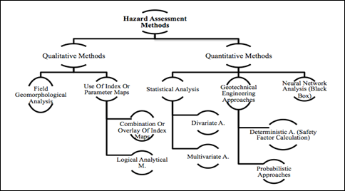
Figure 1: Classification of landslide hazard assessment methods
Source: Crozier and Glade 2004
4. OBJECTIVES AND METHODOLOGY
Most of the landslide studies are conducted to address technical issues in spatial prediction of landslides, while the research on the experts of (slope stability management & risk practice) perspective is in short supply. Urge that in planning landslide awareness programs and decent hazard mitigation measures, it is first necessary to determine experts and relevant authorities point of view in landslides risk assessment and the implementation on future slope instability planning. Second, although many countries including Malaysia have general national slope management plans for disaster preparedness such as NSMP 2009-2023, there are still no exclusive approaches for different regions with different characteristics where the experts can use this estimation to make certain decisions regarding site suitability and causal factors triggering landslides, type of development, and appropriate mitigation measures.
Descriptive analysis and empirical evidence provides predominantly sufficient analysis towards the relation between the underlying causes of landslides, community awareness, perceptions of risk concerns and conclude expert standpoints of current mitigation measures on national Landslide Risk Management (LRM) in Malaysia and by means of the operational capability of National Slope Master Plan (NSMP 2009-2023) within the risk prone areas. Hence, for the benefit of this research paper questionnaire survey is utilized for acquiring information on landslide expert’s attitude, knowledge, and perception towards specific hazard issues. Therefore, the study employs the same data collection approach for the same reason towards a specific environmental risk practices and mitigation measures.
5. ANALYSES AND DISCUSSION
Many research have been utilized on the socioeconomic impacts of landslides on the built environment (Alimohammadlou et al, 2013). However, relatively few of them have discussed the effects and importance of landslide risk analysis for the operation of hazards mitigation measures that would lead to adequate supply on the implementation of landslide management procedures and field conductance thus landslide risk assessment is a vital method for disaster management, hazards mitigation and planning development activities in mountainous terrains of tropical environments as in Malaysia.
5.1 NSMP and PWD Operational Capability
Public Works Department (PWD) operating performance and National Slope Master Plan (NSMP 2009-2023) were examined based on current status, mitigation strategies, workshops attendance, needs and constraints, frameworks and operational capabilities, risk map creation and future enforcement of planning obligations.
a. NSMP 2009-2023 Current Status, Needs and Constraints
Finding of this section have shown high agreement from the respondents with high indication at 81.25%, this implies strong satisfaction from respondents regarding NSMP 2009-2013 comprehensive plans and constraints. Thus, such strategic directions, action plans and key performance indicator measures, the NSMP 2009-2023 would indeed help planners and decision makers for setting priorities on what needs to be done to stem the increasing tide of landslides hazardous events in Malaysia. The finding results have been supported by and work out along with many experts’ reviews and comments on NSMP 2009-2023. Among these experts whom participated on the comprehensive plan Dr. Dave upon the completion of the NSMP and in 2012 Dr Dave says “I was fortunate to have the opportunity to participate in this project in a small way as an expert reviewer it was one of the most enjoyable tasks that I have undertaken in my professional career. The resulting document is large and very comprehensive, covering everything from hazard assessment through loss estimation, training, emergency response and regulations.
b. PWD Landslides Mitigation Strategies
The results revealed that Malaysian PWD has remarkable contribution towards public awareness, education strategy, hazard mapping, assessment strategy, beside early warning system and real–time monitoring, all of these strategies were well contributed via PWD according to the findings and experts view 50% agreed (all of the previous strategies), results implies appositive trend of respondents toward the PWD strategies which contributes in landslides mitigation system that would lead to multi geo-hazard decision support system and engineering mitigation, monitoring, planning and management in term of landslide monitoring procedures and mitigation measures.
c. Frequency of Attending Conferences/Workshops Conducted by PWD
The result illustrated a high percentage with 56.25% who have attended 1-2 times a year this implies the majority of the respondents are a good participators in conferences and workshops conducted and organize by PWD, so they can update their knowledge, sharing ideas, and enhancing the working plans and management at PWD. Therefore, environmental and slope engineering workshops and seminars are important to discuss the challenges and having opportunities of communicating environmental issues in a variety of formats, from the written word, performances to ground implementations. All environmental sustainability issues need to be communicated in some fashion, hence conferences allow participants to collaborate, learn and network for success.
d. Slope Engineering Branch (CKC) and PWD Operational Capabilities
The outcome of CKC/PWD shows (it has all it needs to do best) the majority of the respondents strongly demonstrated the percentage of 43.75%, findings imply and imposed that public awareness and education on landslides have to be continuously carried out by PWD, especially for the people who live in landslide prone areas its because PWD & CKC are the only government bodies with the charter to enforce safety guidelines in a lawfully wise and engage in maintenance measures and public awareness etc., furthermore they are the first line of contact with the local residents, thus, it is crucial that CKC authority figure of PWD being well trained and equipped.
Hence, the government support, concerns, and the motivation of all other stakeholders are highly required. Beside collaboration among all segments of society have to be well merged for best parties contribution. However, slope failure assessment and management in Malaysia is just in the initial phase. There are many things that need to be considered especially on inventorying and data collection of slopes for effective and efficient planning purposes in long and short term wise. Besides that research work conducted at CKC/PWD by Mezughi et al, (2012) have come with a different approach and reported that; one of the major challenges for PWD is to convince the government to provide funding for mitigation measures instead of paying dearly for repairs. Hence it’s recommended further research to investigate more on the debate of the effectiveness of PWD framework and operational capabilities.
e. NSMP Implementation towards Hazard and Risk Map Creation
The result implied that the majority of respondents have agreed with (obligation to be concerned) with 68.75%, this demonstrate a precise clear figure that further implementation of hazard and risk mapping is highly required to be taken into action via PWD and its Slope Engineering Department (CKC), reason being hazard mapping can also be useful method in determining the risks of living in a certain areas or in landslide prone territories within Kuala Lumpur, and it can help people become more aware towards the dangers that might be faced from natural disasters in an areas that subject for slope failure occurrences.
f. The Attainment of NSMP 34 Operation Strategies
The finding indicates that the majority of the respondents have agreed with (10-25%) of NSMP’s 34 strategies so far have been attained. However the crucial debate point is this percentage of accomplishment considered tangible? Reason being that these strategies commenced to be implemented since 2009, and result implies that this percentage of attaining are not satisfying enough within 7 years of contribution and working time. Thus, the importance of the following points raised to be taken into serious actions cause is a need for a substantial change or restructuring of current policy and institutional arrangements and functions via government authorities, including laws that need to be made more relevant, explicit and uniform.
A consensus must be developed amongst all relevant parties involved over and above restructuring national plans to widen the scope of slope failure management system by including landslide hazard awareness, assessment and training programs are necessary for the implementation of a comprehensive slope monitoring and management system. It’s crucial for LRM strategies and objectives to be part of national development plans. However from the above obtained results on NSMP’s 34 strategies, the plan is distinctly facing critical constraints on previous and future implementation wise and the key points in order to wave such limitations is by curing the main challenging parts in landslide hazard assessment is the availability of landslide specialists to carry out the works for long term as well as better understanding of landslide mechanisms is crucial in landslide hazard formulation for boosting the attaining of NSMP’s strategies and ground implementation.
g. NSMP Long-Term Implementation by PWD and Relevant Stakeholder
The results indicated the majority of respondents revealed high agreement with the percentage of 87.50% that (NSMP 2009-2023 strategies and plans going to be carried out and being implemented accordingly for long term by PWD or at its authority departments such as CKC and relevant stakeholders). Hence it would clearly considers providing a long term of promising contribution work and services in order to achieve the goal of NSMP 2009-2023 that aiming to formulate a detailed, comprehensive and effective framework of policies, strategies and action plans to reduce risks from landslides on slopes nationwide, which includes activities at the national, state and local levels in both the public and private sectors.
According to NSMP’s 2009-2023 constraints and needs the main challenge in landslide hazard assessment, implementation and for the entire framework effectiveness is the availability of landslide specialists to carry out the works. As well as decent understanding of landslide mechanisms and the characteristics of soil and rocks in tropical areas as it consider crucial in landslide hazard formulation, also monetary allocation for landslide hazard assessment might be limited. It is therefore the main priority is given to the development of infrastructure, and landslide budget would be only limited to slope repair works and occasionally for slope upgrading works across Malaysia.
5.2 Recapitulation of a Correlation
For long-term implementation of NSMP its clearly requires the combined expertise and effort from a number of diverse authorities, engineering, and social science as well as high skills in computational and data processing for an extended period. However, looking into the plan’s vision from a different perspective it’s noticeable that some of the implementation actions do not have direct bearing on slope instability measures and assessment but are essential for a smooth and effective scope management process the operates by PWD and consolidate via CKC. The NSMP 2009-2023 have been created to be implemented in 3 phases: Phase 1 is from 2009–2013, Phase 2 is from 2014–2018, and the last phase, would be phase 3 is from 2019–2023.
The total cost for the implementation of the action plans is estimated to be approximately USD 248 million over the period of 15 years (Mezughi et al, 2012). The implementation plans and the cost do not include any landslide mitigation measures because information on this matter is not yet available at any sources nor at NSMP’s 2009-2023 context body. Lastly, from all earlier agreements and argumentation with regard to NSMP’s implementation and framework effectiveness it is noticeable that Malaysia government and its related responsible authorities are just beginning to start on a proper slope stability management for a long term. The success of implementing for the NSMP depending on every stakeholder that includes the public, all the decision maker division of the Malaysian government in particular PWD and its authority branches, whereas CKC the most prominent.
5.3 Slope Geometry and Human Activities
The inclusive evaluation via an experts judgment on slope geometry and human behaviour of slope failures has specified increase in landslide events in Malaysia. The hazard distributions are associated with load increase due to civil activities and population pressures in the city public services. landslide caused by human activities is also the important factor for safety threat amongst the urban population. hence, less stable slope geometry created by development or human activities has shown strong indication on occurrences of slope failures in densely districts which in future would expose the urban resident to more serious slope failures. Therefore, the study suggests for a new perspective on sustainable habitation to reduce the frequency and intensity of slope failure in the coming years.
Besides slope mitigation measures to strengthen urban and man-made cutting slopes. These mitigation measures would most effective by the adaptive response of PWD to current and future slope geometry management and its procedures (Figure. 2) illustrates a useful engineering practice of slope-cut and filling at Kuala Lumpur NKVE highway side.
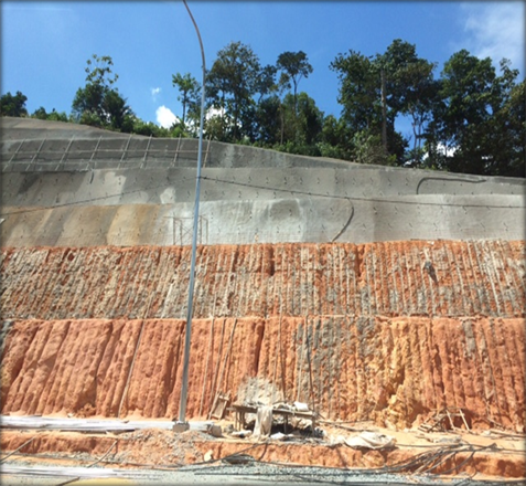
Figure 2. Engineering slope-cut and filling
Source: Research primary data. 29 Nov 2015 at NKVE
6. CONCLUDING REMARKS
The presented research paper has examined experts of landslide point of view and evaluated particular attitude on relevant government authorities associated with hazard practices via the effectiveness of National Slope Master Plan NSMP 2009-2023 on Landslide Risk Management (LRM) throughout Malaysia. Research highlights the benefits of interdisciplinary approach, empirical evidence and descriptive analysis. Therefore, focusing on the physical hazard alone does not explain why people reside landslide prone areas or the factors giving rise to their vulnerability. In like manner, a social science based approach may mitigate the landslide risk altogether and thus fail to consider the potential for a future landslide fatal event. Hence, towards appropriate landslide disaster mitigation a numerous issues could be recommended based on the findings of this research, and considering the stage of development of LRM research and the amplitude of the topic.
Monitoring of slope stability and the utilization of early warning systems, regardless of the high frequency of landslides in Malaysia, monitoring instruments of critical slopes is virtually non-existent, as well as a based system of institutions network, organizations, experts research groups, which capable of routinely and systematically collecting accurate and elaborated information for slopes vulnerable to failure, and particularly after each occurrence of landslides. Moreover, Landslide hazard maps should be prepared for hazard prone areas and high-risk zones in Malaysia. These maps should be used to instruct city inhabitants and to discourage the developers’ construction works in high-risk zones.
In conclusion, towards better forecasting models and risk mitigation strategies. The possibility of establishing a systematic collection and analysis approach of extensive historical information on landslides events, and related natural hazards are highly recommended. This information will greatly contribute to the understanding of the hazard volume of landslides phenomena. The historical inventory would contribute to better determining the susceptibility to the different types of slope failure and mass movement hazards, which remains largely unidentified.
7. REFERENCES
ALEOTTI, Pietro; CHOWDHURY, Robin. Landslide hazard assessment: summary review and new perspectives. Bulletin of Engineering Geology and the environment, v. 58, n. 1, p. 21-44, 1999.
ALIMOHAMMADLOU, Y.; NAJAFI, A.; YALCIN, A. Landslide process and impacts: A proposed classification method. Catena, v. 104, p. 219-232, 2013.
ALNAIMAT, A.; CHOY, L. K.; JAAFAR, M. An Assessment of Current Practices on Landslides Risk Management: A Case of Kuala Lumpur Territory. Geografia-Malaysian Journal of Society and Space, v. 13, n. 2, p.1-12, 2017.
CROZIER, M.J.; GLADE, T. Landslide hazard and risk: Issues, concepts and approach, landslide hazard and risk. Edited by Thomas Glade, Malcolm Anderson & Michael j. Crozier. 2004 Wiley, p.2–40, 2004.
DAI, F. C.; LEE, C. F.; NGAI, Y. Yip. Landslide risk assessment and management: an overview. Engineering geology, v. 64, n. 1, p. 65-87, 2002.
DORREN, L.K., BERGER, F. & PUTTERS U.S. Real size experiments and 3D simulation of rock fall on forest slopes. National Hazard earth system science (6): 145–153, 2006.
EXPACTGO. A total of 1,740 slopes in Kuala Lumpur are prone to landslides. Community, January 7. http://www.expatgo.com/my/2015/01/07/. 16 July 2015.
FELL, R., HO K.K.S. LACASSE, S. & LEROI, E. A framework for landslide risk assessment and management. Proceedings International Conference on Landslide Risk Management. London, Taylor & Francis. 3–25, 2005.
GEO. Government of Hong Kong. Guidelines on the Use of Prescriptive Measures for Rock Cut Slopes Technical Guidance. Notification No13, 2003.
HUAT, L.T.; ALI, F. Slope hazard assessment in urbanized area. Electronic Journal of Geotechnical Engeneering, v. 17, p. 341-352, 2012.
HUI LI, W. Y., JIANG Z. & CHEN M. Landslide mapping, assessment and management. Electrical and Control Engineering (ICECE): 2303–2306, 2011.
JASMI, T. Slop instability and hazard mapping using remote sensing and GIS techniques in the area of Cameron Highland, Malaysia. Malaysian Centre for Remote Sensing (MACRES), 1996.
JKR. Jabatan Kerja Raya Malaysia PWD. National slope master plan: 1–382
KOMOO, I. AZIZ, S., SIAN, L. C. Incorporating the Hyogo Framework for Action into landslide disaster risk reduction in Malaysia. Bulletin of the Geological Society of Malaysia, v.57, p.7-11, 2011.
MALET J.P., & O. Maquaire. Risk assessment methods of landslides. Sixth framework programme, Project Report 2.2, 2007.
MEZUGHI, T. H., AKHIR, J. M., RAFEK, A. G., & ABDULLAH, I. Analytical hierarchy process method for mapping landslide susceptibility to an area along the EW highway (Gerik-Jeli), Malaysia. Asian Journal of Earth Sciences, v. 5, n. 1, p. 13-24, 2012.
OVEN, Katie Jane. Landscape, Livelihoods and Risk: Community Vulnerability to Landslides in Nepal. Ph.D thesis, Durham University, 2009.
PARDESHI, Sudhakar D.; AUTADE, Sumant E.; PARDESHI, Suchitra S. Landslide hazard assessment: recent trends and techniques. SpringerPlus, v. 2, n. 1, p. 523, 2013.
SARO, L; BISWAJEET, P. Probabilistic landslide hazards and risk mapping on Penang Island. Journal of Earth System Science, v.115, n.6 p.661–672, 2006.
WONG, H. N.; KO, F. W. Y. Landslide risk assessment application and practice. GEOReport No. 195, Geotechnical Engineering Office, Civil Engineering and Development Department, 2006.
WU, T.H., TANG, W.H & EINSTEIN, H.H. Landslide hazard and risk assessment. In: Turner, A.K., Schuster, R.L. (Eds.), Landslides: Investigation and Mitigation, Special Report 247, Transportation Research Board, National Research Council. National Academy Press, Washington, DC: 106–120, 1996.
YIN, Pauline Leong Pooi; KRISHNAN, Kumutham; EAN, Catherine Lee Cheng. Evaluation research on public relations activities among public relations practitioners in Malaysian corporations: an exploratory study. The Journal of the South East Asia Research centre for Communications and Humanities, v. 4, n. 1, p. 41-61, 2012.
![]() This
work is licensed under a Creative Commons Attribution 4.0 International
License.
This
work is licensed under a Creative Commons Attribution 4.0 International
License.